|
|
| (8 intermediate revisions by the same user not shown) |
| Line 1: |
Line 1: |
| '''Welcome to the UNLOCK15-Toolbox!'''
| | {{#tweekihide:firstHeading|sidebar-right}} |
| | Welcome to the UNLOCK15-Toolbox - we are collecting tools to empower „agents of change“ from civil society as well as city officials to unlock existing lock-ins. We hope you will find some relevant tools to drive change towards mobility transition in your context! |
|
| |
|
| Consult the [https://www.mediawiki.org/wiki/Special:MyLanguage/Help:Contents User's Guide] for information on using the wiki software.
| | From experience, three types of tools are need for real change: tools to create and communicate evidence, tools to envision possible futures and scenarios and participatory tools for on-site action. |
|
| |
|
| == Getting started == | | {{#arraymap:Evidence,Vision,Action |
| * [https://www.mediawiki.org/wiki/Special:MyLanguage/Manual:Configuration_settings Configuration settings list]
| | |, |
| * [https://www.mediawiki.org/wiki/Special:MyLanguage/Manual:FAQ MediaWiki FAQ]
| | |xxx |
| * [https://lists.wikimedia.org/postorius/lists/mediawiki-announce.lists.wikimedia.org/ MediaWiki release mailing list]
| | |{{#semorg-list:toolbox |
| * [https://www.mediawiki.org/wiki/Special:MyLanguage/Localisation#Translation_resources Localise MediaWiki for your language]
| | |links= |
| * [https://www.mediawiki.org/wiki/Special:MyLanguage/Manual:Combating_spam Learn how to combat spam on your wiki]
| | |title=xxx |
| | |query=[[semorg-toolbox-tool-type::xxx]][[semorg-toolbox-visualisation::+]] |
| | |card template=toolbox |
| | |nopagination |
| | |limit=3 |
| | |order=rand |
| | |intro=<div class="mb-2">{{xxx-intro}}</div> |
| | }}[[xxx|more tools for xxx…]] |
| | | |
| | }} |
Latest revision as of 14:04, 19 May 2026
Welcome to the UNLOCK15-Toolbox - we are collecting tools to empower „agents of change“ from civil society as well as city officials to unlock existing lock-ins. We hope you will find some relevant tools to drive change towards mobility transition in your context!
From experience, three types of tools are need for real change: tools to create and communicate evidence, tools to envision possible futures and scenarios and participatory tools for on-site action.
This type of tools help you to collect evidence, which supports the change you are aiming for. Some tools also allow crowd-based approaches to involve citizens in a broad manner. Evidence helps to convince decision makers to back-up change.
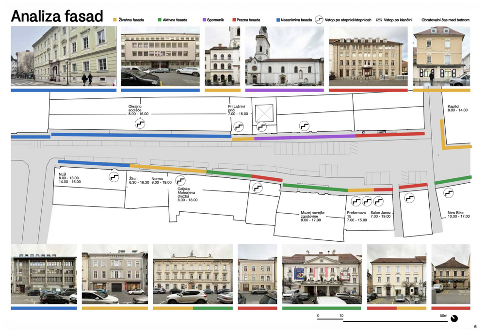
"We need parking space otherwise our shops will die!" This is an argument often brought forward by opponents of street transformation. The urban design studio prostorož confronted this claim with evidence. They analysed the facades of the street by the following categories: Lively facade, active facade, monument, empty facade, unremarkable facade. They could show that a lot of the ground floor was at that point in time not occupied.
prostorož combined this analysis with analysing parking place occupancy and human behaviour to build an even stronger argument: A street full of cars is not helping shops at the moment. By combining all these analysis they managed to convince the decision makers to give that street a human friendly makeover!

You have a very clear picture of the local change you want to achieve? You want to show decision makers how much support your vision locally has? Then a petition might be your cup of tea to drive change.
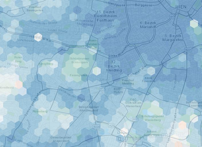
The map shows how close services are if one lives in different areas of the city: in red areas the time needed to access the closest services is on average higher than 15 minutes, while the blue are 15-minute areas. We consider the average time of accessibility to the closest 20 POIs.
more tools for Evidence…
In this category you find tools that help you to create a vision of what you are aiming for. A strong vision is key for driving change because it helps you to grow as a movement and to shift public opinions. This category also includes tools that help you envision how you want to work together as a group.

Sociocracy is a governance and decision-making method designed to enable self-organization in groups and organizations without traditional top-down authority. Rather than relying on majority votes or hierarchical decisions, sociocracy is based on the consent principle: a decision is valid as soon as no member of the circle has a serious, well-founded objection — meaning arguments count, not the number of votes.

This tool is a quick, easy tool that is effective at helping groups understand the different roles in making groups work: different leadership skills.

The Vienna Climate Team is a participatory initiative in Vienna that brings residents, local stakeholders, and the city administration together to co-develop and implement climate protection measures at the district level. It enables citizens to submit ideas, collaborate with experts, and take part in decision-making processes related to urban sustainability.
more tools for Vision…
Small steps towards the realisation of local change can help to make the vision tangible and also easier to be discussed. Tools for action help to make the impact of change tangible and involve local communities.
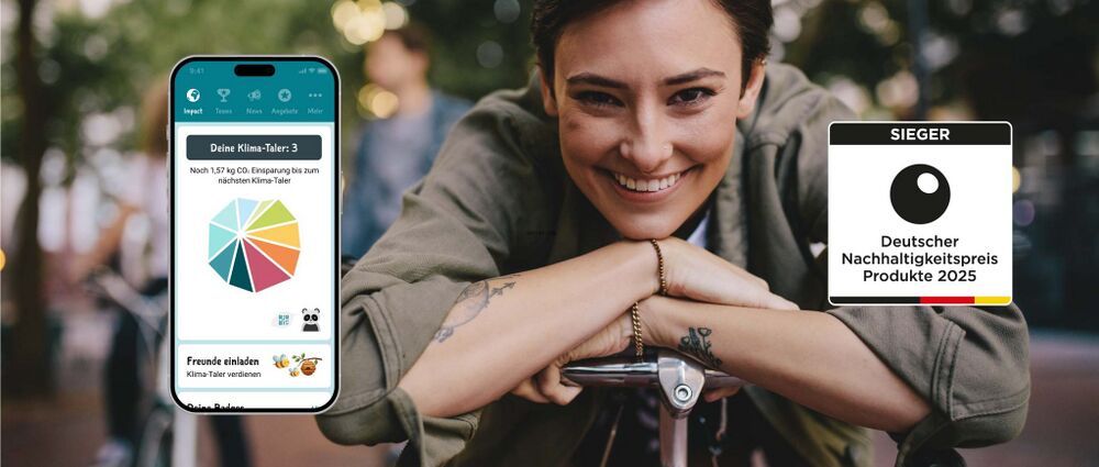
Gamification is the application of game-design mechanics — such as points, rewards, competitions, challenges, and progress tracking — to non-game contexts in order to motivate behaviour change. In the context of urban sustainability and mobility, it turns everyday choices like taking public transport, cycling, or saving energy into visible, rewarding actions that feel meaningful and fun rather than obligatory.

Tree budget Graz is an innovative financing model introduced by the City of Graz to systematically fund the planting and maintenance of urban trees. It draws from three sources: compensation fees collected under the city's tree protection ordinance (which requires replanting or financial compensation when trees are removed), voluntary tree sponsorships open to individuals and companies, and project-specific budget approvals by the city council. Together, these streams create a dedicated financial pool that ensures greening efforts are not dependent on a single, uncertain budget line.
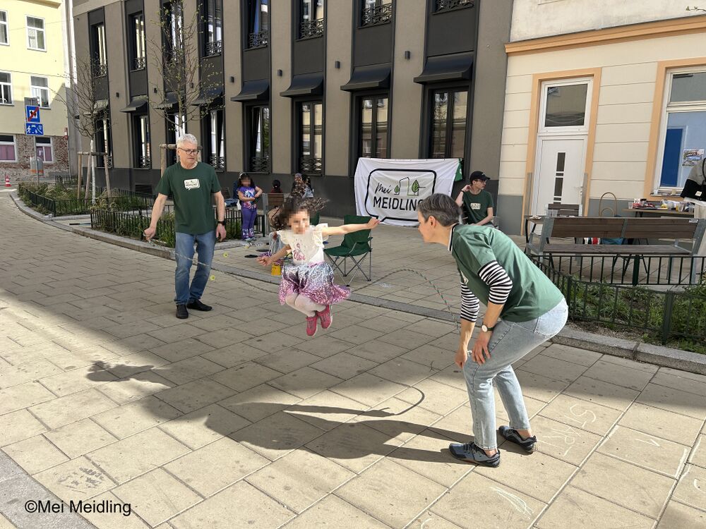
How your neighbourhood should look like should be a concern of everybody living there, right? In reality it can be hard getting in touch with people about this topic. Especially if they have a different social or cultural background than you. The initiative "MeiMeidling" faced this challenge and had a breakthrough: They blocked an alley from cars and organised street games. Especially the big skipping rope was loved by the kids. In no time the parents joined. For the first time members of the initative talked to neighbours, that were strangers to them until this moment. Knowing your neighbours does not only increase life quality but also paves the way for better communication about how this neighbourhood should look like in the future.
more tools for Action…